
by Leanna Wigboldus
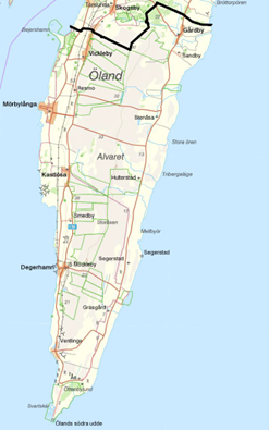
Figure SEQ Figure \* ARABIC 1: Map of the World
Heritage site portion of Southern Öland, with divisions (Moreau and Folkesson,
2015)
The island of Öland (Sweden) is a continuing landscape rich in both cultural and natural values, with the island’s southern region dominated by a World Heritage cultural landscape. The landscape has been evolving for over 10,000 years due to changes in climate and land-use and has been particularly shaped since the introduction of human settlements during the Neolithic (c. 6000 BC) by generations of agro-pastoral practices.
Given the landscape’s continuous interaction between people and the environment, Öland would seem a perfect fit for the Historic Landscape Characterisation (HLC) method, which identifies landscapes as “a form of active material culture that have both shaped people and been shaped by them” (Turner, 2006). The approach views landscapes as dynamic areas of “living, shifting, ever-changing semi-natural patterns” (Clark et al., 2004, p. 3), where change is not only accepted, but sometimes encouraged. The approach is classified as a flexible, locally focused, and value-centered method, with the core components creating broader interpretations of multi-purpose landscapes through an adaptable framework used by individual sites rather than through national/international frameworks (Clark et al., 2004; Herring et al., 2020). The goal is not only to classify time periods and landscapes of historic significance, but also to recognise value in both the ‘everyday’ and ‘special’ historic landscape (Herring et al., 2020) while creating an ‘interpretation’ rather than a ‘judgement’ about landscape values to recognise the influence of local perception, site history, attributes/values, and “other components that cannot be approximated using coordinates” at site-level (Dabaut and Carrer, 2020, p. 155).
In Öland, the characteristic HLC “type” selection seems initially relatively simple. The island is divided into several distinct landscape types including Stora Alvaret (limestone plateau with thin soil cover and high biodiversity), coastal grasslands (habitats for migrating birds and grazing cattle), arable fields (crop growth and traditional agricultural practices), line villages based on water accessibility, archaeological areas, and lakelands. However, once the broad initial assessment is completed, several key questions remain.
The use of GIS and historic mapping records fulfill the HLC goal of creating an analysis of time and history in a landscape to assess long-term change and human intervention, but a site’s true significance, as stated in the Burra Charter (2013), is linked to the people and communities associated with the area. The European Landscape Convention’s definition for landscapes notes that “every individual perceives landscape differently and thus understands its character in various different ways” (Dabaut and Carrer, 2020, p. 163), which can cause issues with a purely tangible analysis. Character-defining elements must include both tangible and intangible heritage features linked not only to location, land-use and spatial configuration, but also to meaning, cultural association, and a history of identity (Prosper, 2018). The reason behind the shaping of the landscape is an essential element that seems to be missing in this holistic analysis. While HLC aims to provide information on historic natural and cultural processes (while also considering local perspectives and values), what happens when there are no longer any ‘tangible’ elements directly linked to these ideologies?
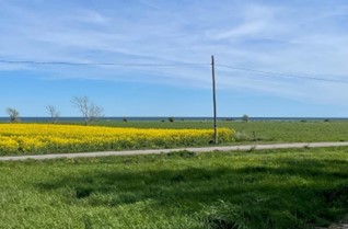
Photo by the author
For example, in Öland, from 1569 to 1801, the entire island was claimed as a Djurgårdsinrättningen (hunting park), dedicated to the King of Sweden’s exclusive use. While the landscape continued to be occupied and farmed by locals during this period, resources and land-use were controlled off-island by the Swedish crown, resulting in over two centuries of enforced restrictions and land development regulations. While historical mapping analysis may reveal this physical lack of use, the reason behind it could remain undiscovered unless linked directly to historical and local records (both tangible and intangible). A purely tangible analysis also disregards how these regulations impacted Öland’s relationship with the Swedish crown and the island’s infrastructural/economic development, both of which have shaped current local identity. Intangible elements, for example traditional field names, local languages, and oral histories could build a more comprehensive and holistic understanding of the landscape.
Similarly, the seascape of Öland is integral to the island’s identity and history as a fishing area and trade route in the Baltic. However, during individual site analysis in the HCL training during the Heriland Blended Intensive Programme, it was noted that unless the seascape assisted the landscape’s ‘agricultural analysis’, it would not be included in the assessment. While this may be generally reasonable, in this case the seascape is closely linked to the intangible site elements such as identity, local history, and language. Analysis of characteristics must be structured under the HLC process, but a ‘holistic’ understanding of landscapes is incomplete without equal consideration of both tangible and intangible characteristics, even if these elements reach beyond the scope of a particular landscape analysis.
As HLC emphasises the use of local and stakeholder perception and the inclusion of all viewpoints, it may be useful to consider who has input into value assessments. Should it extend beyond those with direct site involvement to include national and international tourists who flock to the northern beaches in summer months and double the island’s population? Or the perceptions of Kalmar’s residents (the closest mainland city to Öland) where historic tensions exist between islanders and mainlanders? The perception of a tourist visiting the island for a beach vacation will differ from that of a local farmer residing on Öland, especially as these are mainly based on personal experiences and self-identification with the area (Aldred, 2007). The HLC approach encourages a “subjective interpretation of material objects, recorded as objectively (or rather as transparently and repeatedly) as possible, but analysed by subjective interpretation” (Fairclough, 2006, p. 212). However, such subjectivity could create tensions if all viewpoints are granted equal consideration, as evidenced above.
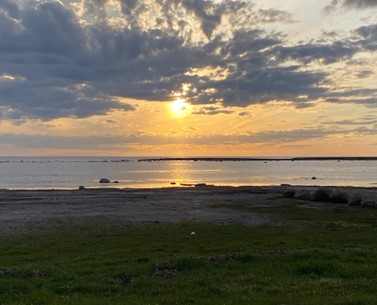
Photo by the author
While challenges with the simplification of landscape structures in relation to historic complexities are noted, HLC datasets are “aimed at addressing specific research questions and understanding spatio-temporal patterns that might be significant to inform future landscape development” (Dabaut and Carrer, 2020, p. 159). Combined with other disciplines, HLC can empower local communities through programs like a ‘Public Participatory GIS’ approach where participants identify locations digitally which are then overlayed and connected to values related to landscape perceptions/qualities to inform future land use (Dabaut and Carrer, 2020). HLC could be used to measure landscape-level changes, map ecological characteristics, and create natural/cultural landscape assessments which could assist in future challenges like “accommodating the effects of climate change, framing the design of environmental growth, securing a place’s cultural distinctiveness, supporting the attachments that individuals and communities have to place, or informing a sustainable visitor economy” (Herring et al., 2020). These future opportunities would be enhanced by including intangible elements and local perceptions to provide a complete, holistic landscape character.
From insights gained during the Heriland course, HLC is a useful tool for assessing tangible aspects of historic landscapes, but the scope could be broadened to include further intangible elements and encourage a more robust understanding of values and perceptions. As noted by Fairclough (2006), while HLC attempts to situate itself in perceptions of ‘place’, the question of value perceptions in site assessment is an ongoing debate, and could be considered as a further area for focus in the evolution of the HLC assessments.
References:
- Aldred, O. (2007) ‘Identifying and assessing landscape through historic landscape characterisation’, Effects of Afforestation on Ecosystems, Landscape and Rural Development: Proceedings of the AFFORNORD Conference. Reykholt, Iceland, 18-22 June. Reykholt: Stationary Office Books
- Clark, J., Darlington, J., and Fairclough, G. (2004) Using Historic Landscape Characterisation. Lancashire: English Heritage and Lancashire County Council.
- Dabaut, N. and Carrer, F. (2020) ‘Historic Landscape Characterisation: Technical Approaches Beyond Theory’, Landscapes, 21(2) pp. 152-167
- Fairclough, G. (2006) ‘Large Scale, Long Duration and Broad Perceptions: Scale Issues in Historic Landscape Characterisation’. In: Lock, G., Molyneaux, B.L. (eds) Confronting Scale in Archaeology. Boston: Springer.
- Herring, P., Dabaut, N. and Last, J. (2020) ‘Where Next for Historic Landscape Characterisation (HLC)?’, Landscapes, 21(2), pp. 98-112
- ICOMOS Australia (1987) The Australia ICOMOS charter for the conservation of places of cultural significance (the Burra Charter). Sydney: ICOMOS Australia
- Prosper, L. (2018) ‘Perspectives on Landscape: Some Canadian approaches’, In: Fairclough, G. et al. eds. Routledge Handbook of Landscape Character Assessment: Current Approaches to Characterisation and Assessment. London: Routledge.
- Turner, S. (2006) ‘Historic Landscape Characterisation: A Landscape Archaeology for Research, Management and Planning’, Landscape Research, 31(4), pp. 385-398.
- Moreau, A. and Folkesson, P. (2015) Landskap att värna om: Gärdesgränser och bete på södra Öland. Kalmar: Länsstyrelsen Kalmar län.
- Wigboldus, L. (2022) The landscape has been used for agricultural and pastoral practices for hundreds of years and continues to be used in similar ways today. [Photograph]. Öland: Leanna Wigboldus
- Wigboldus, L. (2022) A relationship with the sea has always been important for both natural and cultural values on Öland [Photograph]. Öland: Leanna Wigboldus
About the author
Leanna Wigboldus is a PhD scholar at the University College Dublin, Ireland. This Blog post is based on her PhD research and inspired by her participation in the Heriland Blended Intensive Programme on “Cultural Heritage and the Planning of European Landscapes”, October 2022.
Contact Leanna Wigboldus: leanna.wigboldus@ucdconnect.ie
About the Heriland Blended Intensive Programme
Are you interested in participating in the next iteration of the Heriland Blended Intensive Programme “Cultural Heritage and the Planning of European Landscapes”?
Contact Niels van Manen: n.van.manen@vu.nl.